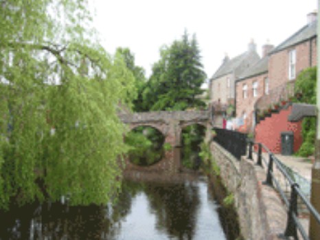
Alyth is a small town in the Strathmore valley at the foothills of the Grampian Mountains, currently with a population over 2,000 people. It is approximately 16 miles north-east of Perth and 14 miles north-west of Dundee. The town is situated on a flat near the base of a hill, with excellent springs on all sides, and a small river (Alyth Burn) running through the lower town as shown in the picture to the right.
The name Alyth was likely derived from the Pictish-Welsh name ar leithio meaning a place overlooking soft ground subject to flooding. There were references to Alyth in the Registrum Vetus de Aberbrothock so it can be presumed that the town existed at least a thousand years ago. King William the Lion (King of Scotland from 1143-1214) signed charters in Alyth relating to the Arbroath Abbey in 1200, 1201, and 1211. It was made a Burgh of Barony by James III in 1488. That charter gave the town the right to trade, although it was not at the level of Dundee's Royal Charter. During the next several centuries, Alyth prospered as the cattle droving, wool, jute, and linen trades grew.
Alyth parish's chief antiquity is an oval fort on Barry Hill that is 450 feet in circumference and was defended by a rude stone rampart. Many scholars believe that Vanora (Queen Guinevere) was abducted and held captive there by the Pictish King Mordred. According to local tradition, when Guinevere was returned to Arthur after her enforced infidelity, Arthur sentenced her to be torn apart by wild beasts. He then ordered her remains to be buried in Meigle.
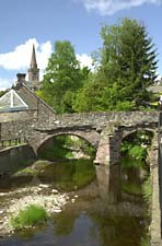
The town developed around the Alyth Burn with one of its historic sites being the Pack Bridge crossing that burn. This bridge (see right), intended for pack horses, is 5'2" wide and existed prior to 1624. The street leading to the bridge is Toutie Street, so named due to the practice of the herder tooting his horn at dawn and dusk as he collected and returned each resident's cow which grazed on the Hill of Alyth. The picture at the very top of this page also features the famous bridge.
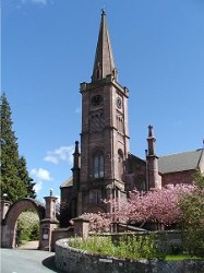
One of the most famous landmarks in Alyth town is the parish church that was built in 1839. The high spire is the church's most striking feature as seen in the picture on the left. It is also well known for the Pictish standing stone in the porch (not visible in the picture). However, there has been a Christian presence in Alyth since the 6th century through a contemporary of St Columba named St. Moluag.
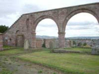
The older part of Alyth is dominated by the Arches - the remnants of the old sacristy of the pre-reformation Church of Alyth that was dedicated to St. Moluag.
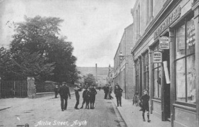
With the introduction of the railway in 1861, a new era of prosperity and activity came to the parish. In 1862, the factory of David Smith was started and, with the introduction of machinery, the end of the hand-loom was in sight. In the 1870's the town's staple industry was the manufacture of brown and other linens by two mills. There was also jute spinning with bleaching, dyeing and calendering as well as a woolen factory. In the background of the picture to the left, you'll see smokestacks of some factories as well as a glimpse Alyth Hill
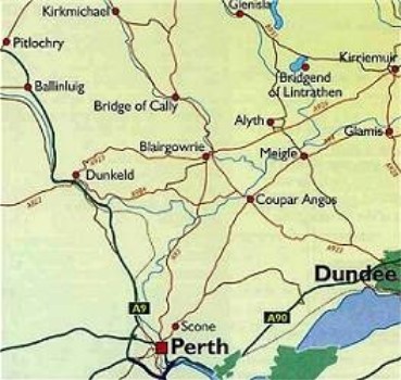
The last image is of a map of east Perthshire showing the relative proximity of Dundee, Meigle and Alyth. To give you a sense of the scale, Alyth and Meigle are 3.5 miles apart.
Sources
Various web sites, including
The Gazetteer for Scotland (http://www.geo.ed.ac.uk/scotgaz/towns/townhistory141.html)
Statistical Accounts of Scotland (http://stat-acc-scot.edina.ac.uk/)
Further reading: Wighton Families in Alyth