| Life of a CPR Surveyor |
|
|
|
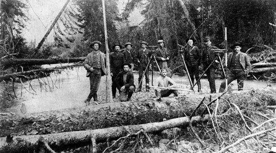
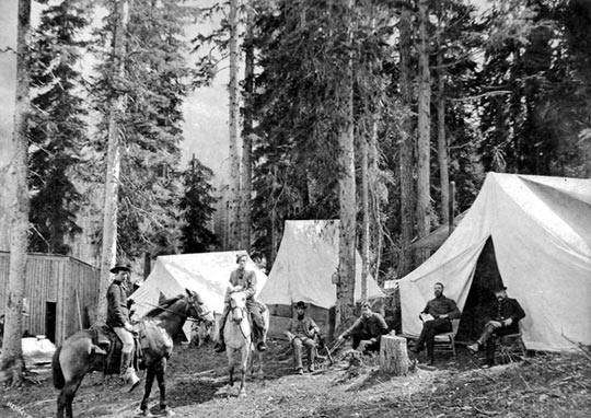
The CPR railway was completed in 1885 and, in 1887, the western end of the line was extended from Port Moody to Vancouver. Obviously, this was well before 1907 when Harry took on the job of surveying for the CPR. However, in the pictures above, we can get a sense of the living and working conditions of CPR surveyors who worked in the field around 1884. To the left, an engineering survey party is near the summit of the Rockies close to the Great Divide. To the right, surveys for the CPR line were carried out by engineers travelling on horseback or by foot. This image shows an engineering party camped in Rogers Pass near the summit of the Selkirk Range. While the work on surveying the main lines had been completed by the time Harry was hired, plenty of new rail lines were being developed. The main lines brought in lots of immigrants and allowed goods to be transported. Commercial and population increases promoted additional demand for branch lines that connected to the main lines. By the 1900s, the railway system in western Canada was rapidly being extended. For example, the CPR had leased a line in 1901 from the Vancouver and Lulu Island Railway that went from Steveston to English Bay, 14 miles distant. However, it's doubtful that Harry would have been doing his surveying in the Vancouver area, whether it was for railways or other of the CPR's property. Most of the planning for the development of the CPR land in Vancouver had been completed by 1900. |
 |
 |
|
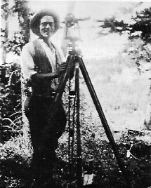
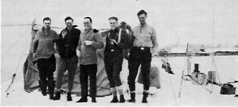
It's possible that Harry could have been part of a survey team working on expanding the CPR connecting lines, perhaps in BC. If he was working in the field, his work might have been in rough terrain and we could presume that he would have been camping in the rough. As late as 1927/28, a survey company was still traveling by horse, with equipment and supplies drawn by teamsters in wagons, with the crew living in tents, perhaps even into the winter. Above left is a picture of a transit man in 1927. Above right, this survey crew included an axman, a teamster, an instrument man, a topographer, and an engineer leading the party. |
 |
|
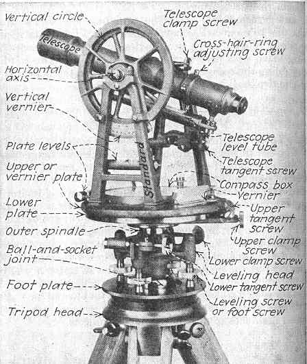
Having now learned just a little about a surveyor's life in the 1880s, and then the 1920s, let's see what I can find for you in the 1900s. Above is a picture of a transit, a surveyor's key tool, that would have been in use during this period. I found a web article that described the life of a survey party in the 1900s. That work was done in northern Ontario, but it likely would apply to BC as well. They worked in all seasons, usually in very remote areas, for months at a time. Surveying parties consisted of a surveyor, an engineer to manage the project, a cook, possibly a forester, and any number of axmen and chainmen to cut and measure the line with a chain. They required snowshoes every day until the middle of April and lived in tents with only an outside fire for warmth. Their food was of the usual kind for surveys in the early days — flour, pork, beans, split peas and tea, with a little sugar for the exclusive use of the cook. They carried a muzzle-loading rifle and shot a caribou, caught a few fish through the ice, and shot partridges with a horse pistol during the winter. Here's another source that talks about the members of the survey team and their roles in the early 1900s. The Chief of the party performed reconnaissance on horseback for the survey team and was in change of the project. From his reconnaissance, he'd produce a sketch of the possible route. In BC, he'd build the line in a series of straight sections that made their way around natural obstacles. Grades were supposed to be no more than 2 units for every 100 units travelled. Curves were supposed to be no more than 10 degrees maximum with a radius of 573 feet if possible. The Party Chief would give his sketch to the Topographer who was in charge of interpreting the map and supervising the party's work during the day. As such, he was considered second in command. He was expected to be experienced in construction and in all the instruments. He had responsibility for all the tripod-mounted instruments and the staff who did the detailed measuring work. As the team measured out the route, he and the Chief would get a feel for the extent of the construction work that would have to be done, for example, grading, timber clearing, rock removal, bridges, tunnels, embankments, and so forth. These were all recorded in notes. Also recorded were probable angles, gradients, and distances. The Transitman maintained and operated the transit (see picture above) which measured both horizontal and vertical angles and straight lines. A flag held up by the Rear Flagman allowed the transitman to line up his next sighting point with his previous. He would use elaborate processes and mathematical calculations to nail down precisely where each important feature in the proposed railway line was. The transitman also kept alignment notes and assisted in mapping the line after work was completed for the day. The Draftsman in the survey party produced a map of the local area around the potential railway route with help from other members of the team like the transitman. Someone in head quarters would eventually evaluate whether this particular line was worth the estimated cost to build it and operate it. Sharp curves and steep grades wouldn't go over well in headquarters. |
 |
|
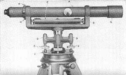
The Levelman maintained and operated the level - the instrument used to survey the gradient of the line. Above is a dumpy level so named because its original design was short and stout, or dumpy. It was the most common level used. In the picture, A is the telescope and C is a spirit level. The levelman also assisted in mapping at night. The skills needed for this job were less than for the transit, so the job might be filled by some young graduate such as Harry. The level was set up to always sight parallel to level ground, aiming at a calibrated rod held by the Rodman. The Levelman than would read the height difference on the rod through the telescope. After chaining (measuring) the distance to the rod at ground level, he could can then calculate the gradient. The Head Chainman was the foreman of the people clearing, chaining, and staking the line. He would measure the distance with a 100 foot chain and set the pace for the party - considering the relative speeds of the Front Axman who was in charge of the axmen who were clearing the ground in front), the transitman, levelman, and other party members. The Rear Chainman brought up the rear of the chain and assisted in counting off each 100 foot segment - and fractions of 100 when necessary. The Stakeman was responsible for semi-permanently marking the spots used by the transitman and levelman for their measurements, and any other special landmarks. Other party members were the the cook, boss teamster, and other teamsters and axmen. |
 |
|
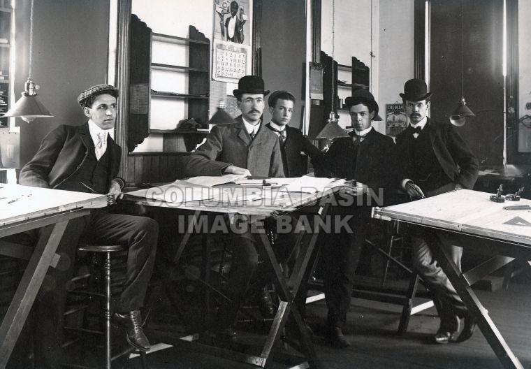
I have to emphasize that we have no evidence that the surveying work that Harry did was in the field. Above is a picture of some young CPR surveyors working in Cranbrook in the 1900s. This is the kind of environment I could see Harry working in. An office environment with drafting tables. I suspect that if Harry had indeed been traipsing around BC on a horse and living in a tent, there would have been some stories of his experiences that would have drifted down the generations. So, perhaps the above picture is one you want to take as the more realistic. Sources Various websites, including: Canadian Pacific: http://www.cpr.ca/en/about-cp/our-past-present-and-future/photo-gallery/building-the-railway/Pages/default.aspx A History of the Canadian Pacific Railway(1923), by Harold A. Innis, Ph.D. http://www.gutenberg.ca/ebooks/innis-historyofthecpr/innis-historyofthecpr-00-h.html#CHAPTER_IVB Surveying for the CPR, 1927/28: http://heinsburg.ca/surveying-cpr How researching a lake's history changed my view of surveying. http://pogamasing.com/2011/11/08/how-researching-a-lakes-history-changed-my-view-of-surveying/ CPR surveyors in Cranbrook: http://www.basininstitute.org/search/details.html?id=10463#.UeCSgVMTEvo |